- Posts: 5
- Thank you received: 1
The 'Introduce yourself' Thread
- baba
- Offline
- New Member
-

Less
More
01 Dec 2012 22:50 #3671
by baba
Replied by baba on topic The 'Introduce yourself' Thread
wow thanks for the link thats great stuff thank you baba love this web site its great thank you sir
Please Log in or Create an account to join the conversation.
- dklim
- Visitor
-

02 Dec 2012 13:53 #3672
by dklim
Replied by dklim on topic The 'Introduce yourself' Thread
My uncle was also a mechanic at Tilly Whim, Corporal Hugh Drummond RCAF.
Please Log in or Create an account to join the conversation.
- pauline
- Offline
- Senior Member
-

Less
More
- Posts: 277
- Thank you received: 12
02 Dec 2012 15:59 #3673
by pauline
Replied by pauline on topic The 'Introduce yourself' Thread
I'm not one of those who can contribute much to this site but let me be one of the first to say thank you Chris for your part in setting it up. I, like you, became interested in this subect as a result of my father who served at Wing airfield in WW11, my cousin's husband who flew in Lancasters from Wickenby, my cousin who served as a WAAF at Tangmere, and her mother who was based at Alconbury in the NAAFI. I have found so much of interest to me, and everyone is so friendly. I have had answers and help with so many questions, and, lucky me, I live in East Anglia!!
Pauline.
Pauline.
Please Log in or Create an account to join the conversation.
- PETERTHEEATER
-

- Offline
- Platinum Member
-

Less
More
- Posts: 10905
- Thank you received: 772
04 Dec 2012 06:45 #3674
by PETERTHEEATER
Replied by PETERTHEEATER on topic The 'Introduce yourself' Thread
From the web:
Crab, crabfat - (RN) A member of the Royal Air Force. From the light blue color of the uniform, which is the same as that of the grease (known as ‘crabfat’) used on gun breeches, etc., in the RN. Accounts vary, but apparently the grease was called ‘crabfat’ because it resembled in color the ointment used to treat sailors for ‘crabs’ (pediculosis pubis, genital lice), and of which fat was a major constituent.
Crab, crabfat - (RN) A member of the Royal Air Force. From the light blue color of the uniform, which is the same as that of the grease (known as ‘crabfat’) used on gun breeches, etc., in the RN. Accounts vary, but apparently the grease was called ‘crabfat’ because it resembled in color the ointment used to treat sailors for ‘crabs’ (pediculosis pubis, genital lice), and of which fat was a major constituent.
Please Log in or Create an account to join the conversation.
- PETERTHEEATER
-
- Offline
- Platinum Member
-
Less
More
- Posts: 10905
- Thank you received: 772
04 Dec 2012 07:38 #3675
by PETERTHEEATER
Replied by PETERTHEEATER on topic The 'Introduce yourself' Thread
The Sker DA can be seen on Old Maps 1966 OS 2500 map now that the AP has pointed the way (no pun intended).
Probably one of the Margham Sands ranges (I think PNK )you had more than one unconfirmed location for the Margham (A) range and one (target at SS783778) was around this area.
For the Ogden by Sea DA, if you look closely on Google Earth, both '2009' views appear to show the remains of the shaft and LH barb.
Probably one of the Margham Sands ranges (I think PNK )you had more than one unconfirmed location for the Margham (A) range and one (target at SS783778) was around this area.
For the Ogden by Sea DA, if you look closely on Google Earth, both '2009' views appear to show the remains of the shaft and LH barb.
Please Log in or Create an account to join the conversation.
- theo barten
-

- Offline
- User is blocked
-

04 Dec 2012 14:21 #3676
by theo barten
Replied by theo barten on topic The 'Introduce yourself' Thread
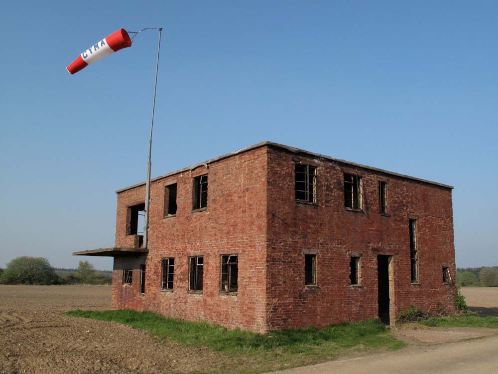
As an infographic designer I also use photography. Being interested in everything concerning aviation i often travel to the UK to photograph control towers of abandoned airfields.In the near future we are going to publish a photobook on the subject (from Acaster Malbis to Winkleigh) called: Along the controltower. Hereby an example. We also publish photobooks on civic use of soft-skin trucks from WWll:
www.frituurzorro.nl
.
I hope op response from members of this forum.
Attached files
This image is hidden for guests.
I hope op response from members of this forum.
Attached files
This image is hidden for guests.
Please log in or register to see it.
Please Log in or Create an account to join the conversation.
- Ossington_2008
- Offline
- Platinum Member
-
Less
More
- Posts: 1645
- Thank you received: 163
04 Dec 2012 17:11 #3677
by Ossington_2008
Replied by Ossington_2008 on topic The 'Introduce yourself' Thread
I like the title, has a Hendrix ring! Can't you do Abbots Bromley to Zeals?
Please Log in or Create an account to join the conversation.
- REF
-

- Offline
- Platinum Member
-
Less
More
- Posts: 9794
- Thank you received: 652
04 Dec 2012 17:51 #3678
by REF
Replied by REF on topic The 'Introduce yourself' Thread
Nice photo of the Little Snoring tower theo barten. There are still a few surviving WW2 towers in the UK. Do you have a list of the towers you will be publishing in the photo book?
Please Log in or Create an account to join the conversation.
- mbriscoe
-

- Offline
- Moderator
-

04 Dec 2012 18:21 #3679
by mbriscoe
Don't know how wide your interests are, I am mainly interested in radar and radio sites. There are a couple of sites in Pembrokeshire that were used for some radio tests around the Irish Sea during WWII. I visited one of the Scottish sites used in the tests.
Replied by mbriscoe on topic The 'Introduce yourself' Thread
Yes they are. I've already been out to view the sites at Kenfig and to see if anything remains for the site at Ogmore. I've still got to visit the quadrant tower at Llangennith. If there are more I'd be grateful for any further info. The western boundary for me is the Loughor.
Don't know how wide your interests are, I am mainly interested in radar and radio sites. There are a couple of sites in Pembrokeshire that were used for some radio tests around the Irish Sea during WWII. I visited one of the Scottish sites used in the tests.
Please Log in or Create an account to join the conversation.
- theo barten
-
- Offline
- User is blocked
-
05 Dec 2012 09:07 #3680
by theo barten
Replied by theo barten on topic The 'Introduce yourself' Thread
Hi 'REF'
At the moment we have got 25: Acaster Malbis,Bodney,Bury St.Edmunds,Charmy Down,Chichester,Disforth,Docking,Dunkeswell,Duxford,East Kirkby,Hemswell,Henstridge,Little Snoring,Scampton,Strubby,Sturgate,Tangmere,Tholthorpe,Tockwith,Upottery,Waltham,Wickenby,Wigsley,Winkleigh,York. Complete with the coordinates and Google Earths screendumps.
What we would like: Are there folks among you who can add others to the list? That will make our next visit more simple. We would really appreciate that!!!!
At the moment we have got 25: Acaster Malbis,Bodney,Bury St.Edmunds,Charmy Down,Chichester,Disforth,Docking,Dunkeswell,Duxford,East Kirkby,Hemswell,Henstridge,Little Snoring,Scampton,Strubby,Sturgate,Tangmere,Tholthorpe,Tockwith,Upottery,Waltham,Wickenby,Wigsley,Winkleigh,York. Complete with the coordinates and Google Earths screendumps.
What we would like: Are there folks among you who can add others to the list? That will make our next visit more simple. We would really appreciate that!!!!
Please Log in or Create an account to join the conversation.
Time to create page: 0.159 seconds