- Posts: 12446
- Thank you received: 1029
- Forum
- Open Forum
- Miscellaneous Research Topics
- General Airfield or 20th Century Military Architecture Discussion Topics
- 200 yard Moving Target Ranges
200 yard Moving Target Ranges
- Peter Kirk
-

- Offline
- Moderator
-

Less
More
02 Aug 2009 21:48 #31
by Peter Kirk
No Amount Of Evidence Will Ever Persuade An Idiot (probably not Mark Twain)
Replied by Peter Kirk on topic 200 yard Moving Target Ranges
Dear Confused of Quebec,
It took me a while to realise what you were referring to. After five read throughs I found it. The Towyn Camp you refer to is part of Pembrey Airfield Record Site Plan and one of the many places with Towyn as a name or part thereof. To confuse matters even more the Hells Mouth range is next to a place called .......... Towyn!
My brain is now hurting!
It took me a while to realise what you were referring to. After five read throughs I found it. The Towyn Camp you refer to is part of Pembrey Airfield Record Site Plan and one of the many places with Towyn as a name or part thereof. To confuse matters even more the Hells Mouth range is next to a place called .......... Towyn!
My brain is now hurting!
No Amount Of Evidence Will Ever Persuade An Idiot (probably not Mark Twain)
Please Log in or Create an account to join the conversation.
- Peter Kirk
-
- Offline
- Moderator
-
Less
More
- Posts: 12446
- Thank you received: 1029
10 Aug 2009 16:06 - 04 Jul 2017 15:22 #32
by Peter Kirk
No Amount Of Evidence Will Ever Persuade An Idiot (probably not Mark Twain)
This message has an attachment image.
Replied by Peter Kirk on topic 200 yard Moving Target Ranges
Okay I nearly wet myself when I was looking at old photos of Dorset
This must be number 13, assuming West Freugh is a definite location (and Towyn is not included )
)
It is located near Chickerell at NGR SY648785. I don't know why its there but hopefully somebody does. The site is now built over so Google Earth is not much help, however you can just make out the remaind of the outline.
www.flashearth.com/?lat=50.604838&lon=-2...&z=17.3&r=0&src="msl"
This must be number 13, assuming West Freugh is a definite location (and Towyn is not included
)It is located near Chickerell at NGR SY648785. I don't know why its there but hopefully somebody does. The site is now built over so Google Earth is not much help, however you can just make out the remaind of the outline.
www.flashearth.com/?lat=50.604838&lon=-2...&z=17.3&r=0&src="msl"
No Amount Of Evidence Will Ever Persuade An Idiot (probably not Mark Twain)
This message has an attachment image.
Please log in or register to see it.
Last edit: 04 Jul 2017 15:22 by Peter Kirk.
Please Log in or Create an account to join the conversation.
- carnaby
-
 Topic Author
- Offline
- Platinum Member
-

Less
More
- Posts: 5026
- Thank you received: 440
10 Aug 2009 18:15 #33
by carnaby
Brilliant find Peter. I jumped to the location before reading the rest of the post and my first thought was 'Why is it there?'
As you say part of the outline is just visible. Something has been built on the old turret stand , but it looks a bit modern to me.
Graham
Plan A is always more effective when the problem you are working on understands that Plan B will involve the use of dynamite
Replied by carnaby on topic 200 yard Moving Target Ranges
1) I don't know why its there
2) ... you can just make out the remaind of the outline.
Brilliant find Peter. I jumped to the location before reading the rest of the post and my first thought was 'Why is it there?'
As you say part of the outline is just visible. Something has been built on the old turret stand , but it looks a bit modern to me.
Graham
Plan A is always more effective when the problem you are working on understands that Plan B will involve the use of dynamite
Please Log in or Create an account to join the conversation.
- Bill
- Offline
- New Member
-

Less
More
- Posts: 7
- Thank you received: 0
10 Aug 2009 19:10 - 09 Sep 2017 17:52 #34
by Bill
Replied by Bill on topic 200 yard Moving Target Ranges
Hi
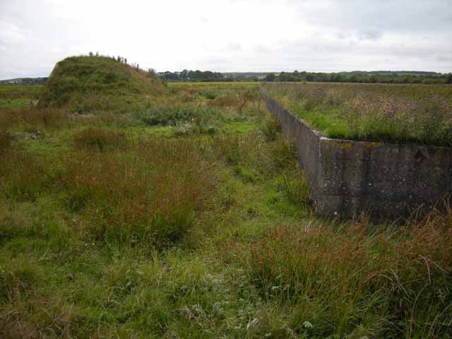
I returned to RAF Wigtown moving target range for a very pleasant, enjoyable summer afternoon and took photos. The site is easily accessible from a public path, but is so out of the way I doubt anyone walks the path let alone visits the range.
The photos start from the hard standing for the gun turret and move around the site in an anticlockwise direction as viewed from Google Maps . There are no artifacts other than concrete, bricks and earth banking. I found a bullet embedded in the rear side of the big wall at the far end of the range.
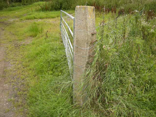
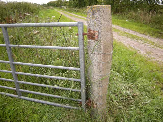
The route of the track is easy to distinguish, there is a surface of big broken stones. I was wondering if the track sleepers were made of concrete? There are fair number of farm field gateposts nearby that look a bit like rail sleepers - the last photos in the photos - but the guage may be too big?
(Next subject - any info known about Pickett-Hamilton Fort pop-up type pillbox at RAF Wigtown? I know it'll be another thread.)
Bill
Attached files
This image is hidden for guests.
This image is hidden for guests.
This image is hidden for guests.
I returned to RAF Wigtown moving target range for a very pleasant, enjoyable summer afternoon and took photos. The site is easily accessible from a public path, but is so out of the way I doubt anyone walks the path let alone visits the range.
The photos start from the hard standing for the gun turret and move around the site in an anticlockwise direction as viewed from Google Maps . There are no artifacts other than concrete, bricks and earth banking. I found a bullet embedded in the rear side of the big wall at the far end of the range.
The route of the track is easy to distinguish, there is a surface of big broken stones. I was wondering if the track sleepers were made of concrete? There are fair number of farm field gateposts nearby that look a bit like rail sleepers - the last photos in the photos - but the guage may be too big?
(Next subject - any info known about Pickett-Hamilton Fort pop-up type pillbox at RAF Wigtown? I know it'll be another thread.)
Bill
Attached files
This image is hidden for guests.
Please log in or register to see it.
This image is hidden for guests.
Please log in or register to see it.
This image is hidden for guests.
Please log in or register to see it.
Last edit: 09 Sep 2017 17:52 by netcompsys. Reason: fixed photos with filename spaces
Please Log in or Create an account to join the conversation.
- Peter Kirk
-
- Offline
- Moderator
-
Less
More
- Posts: 12446
- Thank you received: 1029
10 Aug 2009 19:34 #35
by Peter Kirk
No Amount Of Evidence Will Ever Persuade An Idiot (probably not Mark Twain)
Replied by Peter Kirk on topic 200 yard Moving Target Ranges
They do look like railway sleepers but the fixings are different from those down my way. Are there regional variations? As you say Bill, the guage looks too big for the target range. They also look too new.
Maybe someone will confirm or deny.
Maybe someone will confirm or deny.
No Amount Of Evidence Will Ever Persuade An Idiot (probably not Mark Twain)
Please Log in or Create an account to join the conversation.
- PETERTHEEATER
-

- Offline
- Platinum Member
-
Less
More
- Posts: 10905
- Thank you received: 772
14 Aug 2009 09:52 #36
by PETERTHEEATER
Replied by PETERTHEEATER on topic 200 yard Moving Target Ranges
Late reply; I'm playing catchup after major PC problems.
There was an A/G Range located at Chickerell during WW2 (Chesil Bank) so a controlled danger area was available.
There was an A/G Range located at Chickerell during WW2 (Chesil Bank) so a controlled danger area was available.
Please Log in or Create an account to join the conversation.
- Peter Kirk
-
- Offline
- Moderator
-
Less
More
- Posts: 12446
- Thank you received: 1029
14 Aug 2009 11:57 #37
by Peter Kirk
No Amount Of Evidence Will Ever Persuade An Idiot (probably not Mark Twain)
Replied by Peter Kirk on topic 200 yard Moving Target Ranges
That would be it then. I think Chesil beach is just off the photo I posted.
It's Saturday tomorrow and the late afternnon is when I traditionally look for the MTR at West Freugh and the fuel depot at Peterbrough! Even worse I go over the same ground each time, thinking I must have missed something the last 10 times. I fear it has become an OCD.
It's Saturday tomorrow and the late afternnon is when I traditionally look for the MTR at West Freugh and the fuel depot at Peterbrough! Even worse I go over the same ground each time, thinking I must have missed something the last 10 times. I fear it has become an OCD.
No Amount Of Evidence Will Ever Persuade An Idiot (probably not Mark Twain)
Please Log in or Create an account to join the conversation.
- Peter Kirk
-
- Offline
- Moderator
-
Less
More
- Posts: 12446
- Thank you received: 1029
16 Aug 2009 12:30 - 04 Jul 2017 15:18 #38
by Peter Kirk
No Amount Of Evidence Will Ever Persuade An Idiot (probably not Mark Twain)
This message has attachments images.
Replied by Peter Kirk on topic 200 yard Moving Target Ranges
Perseverance or sheer stubborness sometimes pays off. I am hoping this is the site of the elusive West Freugh MTR.
The overlay map is from 1978 (probably a few years before in reality) and shows the familiar bucket outline. As the site is now unrecognisable it is difficult to confirm but it looks a good fit and is facing the right way.
The overlay map is from 1978 (probably a few years before in reality) and shows the familiar bucket outline. As the site is now unrecognisable it is difficult to confirm but it looks a good fit and is facing the right way.
No Amount Of Evidence Will Ever Persuade An Idiot (probably not Mark Twain)
This message has attachments images.
Please log in or register to see it.
Last edit: 04 Jul 2017 15:18 by Peter Kirk.
Please Log in or Create an account to join the conversation.
- carnaby
-
Topic Author
- Offline
- Platinum Member
-
Less
More
- Posts: 5026
- Thank you received: 440
16 Aug 2009 13:25 - 24 Dec 2017 21:43 #39
by carnaby
Think you're probably right there Peter. Congratulations - what are you going to to next weekend?
Now, Bill's 'railway sleepers' entry(#40 above) jogged my mind and below we have some concrete stuff embedded in the bank above one of the walls at the Millom MTR. (Actually W3 on the plan at the top of this thread).
Any ideas guys ?
Graham
Plan A is always more effective when the problem you are working on understands that Plan B will involve the use of dynamite
This message has an attachment image.
Replied by carnaby on topic 200 yard Moving Target Ranges
Perseverance or sheer stubborness sometimes pays off. I am hoping this is the site of the elusive West Freugh MTR.
Think you're probably right there Peter. Congratulations - what are you going to to next weekend?
Now, Bill's 'railway sleepers' entry(#40 above) jogged my mind and below we have some concrete stuff embedded in the bank above one of the walls at the Millom MTR. (Actually W3 on the plan at the top of this thread).
Any ideas guys ?
Graham
Plan A is always more effective when the problem you are working on understands that Plan B will involve the use of dynamite
This message has an attachment image.
Please log in or register to see it.
Last edit: 24 Dec 2017 21:43 by carnaby. Reason: De-photobucketed
Please Log in or Create an account to join the conversation.
- Peter Kirk
-
- Offline
- Moderator
-
Less
More
- Posts: 12446
- Thank you received: 1029
16 Aug 2009 19:01 #40
by Peter Kirk
No Amount Of Evidence Will Ever Persuade An Idiot (probably not Mark Twain)
Replied by Peter Kirk on topic 200 yard Moving Target Ranges
Re West Freugh - I actually emailed the people at Canmore, about 30mins before I found it, to see if they had it recorded. It would be great if they had photographic evidence to back everything up.
Can't imagine what the curved concrete things are for. The obvious thing would be a circle for something as it doesn't look like ribs for a structure.
Can't imagine what the curved concrete things are for. The obvious thing would be a circle for something as it doesn't look like ribs for a structure.
No Amount Of Evidence Will Ever Persuade An Idiot (probably not Mark Twain)
Please Log in or Create an account to join the conversation.
- Forum
- Open Forum
- Miscellaneous Research Topics
- General Airfield or 20th Century Military Architecture Discussion Topics
- 200 yard Moving Target Ranges
Time to create page: 0.075 seconds