- Posts: 10905
- Thank you received: 772
- Forum
- Open Forum
- Miscellaneous Research Topics
- Where or What is this?
- Something, somewhere near Brunton
Something, somewhere near Brunton
- PETERTHEEATER
-

- Offline
- Platinum Member
-

Less
More
16 May 2013 11:35 #11
by PETERTHEEATER
Replied by PETERTHEEATER on topic Something, somewhere near Brunton
I am surprised that it is on high ground falling around the perimeter. Seems not to have sufficient safety trace for flat trajectory tank shells. Although not prominent in satellite view, the is a long 'embankment' shown on OS.
Please Log in or Create an account to join the conversation.
- Yorkie370
-

- Offline
- Senior Member
-

Less
More
- Posts: 106
- Thank you received: 1
16 May 2013 16:36 #12
by Yorkie370
Replied by Yorkie370 on topic Something, somewhere near Brunton
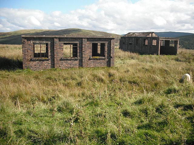
Yes, that aspect surprised me too, Peter. There is always the matter of 'expedient' to consider, and Stobs Camp was long-established, and in remote terrain. If the target was engaged when passing the shortest leg, there's a considerable backstop.
Extant buildings, courtesy of Geograph;
This image is hidden for guests.
A panoramic shot looking from the East can be found HERE.
Extant buildings, courtesy of Geograph;
This image is hidden for guests.
Please log in or register to see it.
A panoramic shot looking from the East can be found HERE.
Please Log in or Create an account to join the conversation.
- PETERTHEEATER
-
- Offline
- Platinum Member
-
Less
More
- Posts: 10905
- Thank you received: 772
18 May 2013 07:56 #13
by PETERTHEEATER
Replied by PETERTHEEATER on topic Something, somewhere near Brunton
I note that on old OS maps the buildings are marked as Settlement implying some ancient Briton anti-Roman defence. Does that hilltop have a history?
Please Log in or Create an account to join the conversation.
- Yorkie370
-
- Offline
- Senior Member
-
Less
More
- Posts: 106
- Thank you received: 1
18 May 2013 16:47 #14
by Yorkie370
Replied by Yorkie370 on topic Something, somewhere near Brunton
I have Camp marked on the map on the hilltop 400m NE of the range buildings. The 1:25,000 historic overlay that I use from NLS (
maps.nls.uk/geo/explore/
) show a very large number of linear and circular earthworks in the vicinity, most probably Bronze- and Iron-Age, and I'd be interested to learn more about their history.
Please Log in or Create an account to join the conversation.
- PETERTHEEATER
-
- Offline
- Platinum Member
-
Less
More
- Posts: 10905
- Thank you received: 772
19 May 2013 09:02 #15
by PETERTHEEATER
Replied by PETERTHEEATER on topic Something, somewhere near Brunton
Camp, earthworks, settlement and tumuli various descriptions across different map ages.
Please Log in or Create an account to join the conversation.
- Forum
- Open Forum
- Miscellaneous Research Topics
- Where or What is this?
- Something, somewhere near Brunton
Time to create page: 0.053 seconds