- Posts: 795
- Thank you received: 13
- Forum
- Open Forum
- Miscellaneous Research Topics
- Where or What is this?
- Help me out - where is this? It's driving me nuts!
Help me out - where is this? It's driving me nuts!
- OneEighthBit
-
 Topic Author
- Offline
- Elite Member
-

Less
More
07 Aug 2011 15:03 #1
by OneEighthBit
Help me out - where is this? It's driving me nuts! was created by OneEighthBit
Hey all.
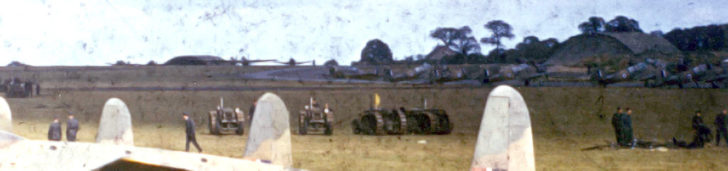
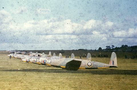
Can anyone help me with this? I was sent the following picture along with some others a while ago by someone who said that they were of No.3 Glider Training school.
I know for a fact it's not No.3 GTS but I can't for the life of me figure out the unit or location without any certainty. As I don't want to get into trouble over copyright I've scaled the pictures down and cropped out a section that might help with identification.
What can I tell you?
Well, first of all they are all Hotspur MkII gliders in 1942/1943 colours and markings. I'm 90% sure the unit is No.1 Glider Training School. I asked the RAF Museum for the movement cards for three of the aircraft who's serials could be seen and the only unit the three have that sync up is No.1 GTS between September 1942 and March 1942. Also in one slide you can see a sky letter P over painted with 39 in white - and this they did when they moved to Croughton. Also the tugs are Miles Master II's which 1 GTS received in August 1942.
The problem is, I can't place the airfield! The above details tie up nicely with them being at Croughton but I cannot get the details in the background to match up with any photo I have of the place.
What's clear from the photo, to me at least, is:
- There seems to be a definite slope to the landing area.
- No evidence of a hard runway.
- The perimeter track at some point has a concave corner.
- There are two blister hangers.
- There appears to be a house between the two hangers on the other side of the hedge on the curve.
Any of you geniuses want to help me identify the airfield and the spot it was taken from?
Attached files
This image is hidden for guests.
This image is hidden for guests.
Can anyone help me with this? I was sent the following picture along with some others a while ago by someone who said that they were of No.3 Glider Training school.
I know for a fact it's not No.3 GTS but I can't for the life of me figure out the unit or location without any certainty. As I don't want to get into trouble over copyright I've scaled the pictures down and cropped out a section that might help with identification.
What can I tell you?
Well, first of all they are all Hotspur MkII gliders in 1942/1943 colours and markings. I'm 90% sure the unit is No.1 Glider Training School. I asked the RAF Museum for the movement cards for three of the aircraft who's serials could be seen and the only unit the three have that sync up is No.1 GTS between September 1942 and March 1942. Also in one slide you can see a sky letter P over painted with 39 in white - and this they did when they moved to Croughton. Also the tugs are Miles Master II's which 1 GTS received in August 1942.
The problem is, I can't place the airfield! The above details tie up nicely with them being at Croughton but I cannot get the details in the background to match up with any photo I have of the place.
What's clear from the photo, to me at least, is:
- There seems to be a definite slope to the landing area.
- No evidence of a hard runway.
- The perimeter track at some point has a concave corner.
- There are two blister hangers.
- There appears to be a house between the two hangers on the other side of the hedge on the curve.
Any of you geniuses want to help me identify the airfield and the spot it was taken from?
Attached files
This image is hidden for guests.
Please log in or register to see it.
This image is hidden for guests.
Please log in or register to see it.
Please Log in or Create an account to join the conversation.
- OneEighthBit
-
Topic Author
- Offline
- Elite Member
-
Less
More
- Posts: 795
- Thank you received: 13
12 Aug 2011 14:13 #2
by OneEighthBit
Replied by OneEighthBit on topic Help me out - where is this? It's driving me nuts!
No-one? I'm stunned! 
Please Log in or Create an account to join the conversation.
- REF
-

- Offline
- Platinum Member
-

Less
More
- Posts: 9794
- Thank you received: 652
13 Aug 2011 01:09 #3
by REF
Replied by REF on topic Help me out - where is this? It's driving me nuts!
I'm not sure about Croughton, there looks to be a hard runway in the second photo
Please Log in or Create an account to join the conversation.
- bvs
-
- Offline
- Premium Member
-

Less
More
- Posts: 607
- Thank you received: 19
13 Aug 2011 07:08 #4
by bvs
Replied by bvs on topic Help me out - where is this? It's driving me nuts!
Croughton certainly has a slope but I can see why the image is tricky to ID
The NW corner of the A/F has a similar taxyway curve but no signs of any Blister sites - although I suppose they could have been obliterated !(unusual)
REF's rwy could be a taxy link or a dispersal link (ie long frying pan)
Shame it is not 3 GTS - at least that would give the options of Culmhead,Exeter and Zeals.
Culmhead has a similar peritrack shape at Trickey Warren,but the dispersal tracks are not quite right and unsure of slope at these locations anyway.
A WW2 site plan would help of course
The NW corner of the A/F has a similar taxyway curve but no signs of any Blister sites - although I suppose they could have been obliterated !(unusual)
REF's rwy could be a taxy link or a dispersal link (ie long frying pan)
Shame it is not 3 GTS - at least that would give the options of Culmhead,Exeter and Zeals.
Culmhead has a similar peritrack shape at Trickey Warren,but the dispersal tracks are not quite right and unsure of slope at these locations anyway.
A WW2 site plan would help of course
Please Log in or Create an account to join the conversation.
- Peter Kirk
-

- Offline
- Moderator
-

Less
More
- Posts: 12446
- Thank you received: 1029
13 Aug 2011 08:07 #5
by Peter Kirk
No Amount Of Evidence Will Ever Persuade An Idiot (probably not Mark Twain)
Replied by Peter Kirk on topic Help me out - where is this? It's driving me nuts!
I can only think of Netheravon but can't confirm this in any way.
No Amount Of Evidence Will Ever Persuade An Idiot (probably not Mark Twain)
Please Log in or Create an account to join the conversation.
- bvs
-
- Offline
- Premium Member
-
Less
More
- Posts: 607
- Thank you received: 19
13 Aug 2011 08:57 #6
by bvs
Replied by bvs on topic Help me out - where is this? It's driving me nuts!
Yes I looked at netheravon as well but could not find a match for location...!
edit...same for kidlington
edit...same for kidlington
Please Log in or Create an account to join the conversation.
- Skellyq
- Offline
- New Member
-

Less
More
- Posts: 6
- Thank you received: 0
01 Sep 2011 20:44 #7
by Skellyq
Replied by Skellyq on topic Help me out - where is this? It's driving me nuts!
Could it be No.2 GTS at Weston on the Green?
Please Log in or Create an account to join the conversation.
- OneEighthBit
-
Topic Author
- Offline
- Elite Member
-
Less
More
- Posts: 795
- Thank you received: 13
01 Sep 2011 21:26 #8
by OneEighthBit
Replied by OneEighthBit on topic Help me out - where is this? It's driving me nuts!
Skelly, It's No.1 GTS for the reasons mentioned in the first post.
Please Log in or Create an account to join the conversation.
- carnaby
-

- Offline
- Platinum Member
-
Less
More
- Posts: 5026
- Thank you received: 440
01 Sep 2011 21:55 #9
by carnaby
Plan A is always more effective when the problem you are working on understands that Plan B will involve the use of dynamite
Replied by carnaby on topic Help me out - where is this? It's driving me nuts!
Not much help but, 1 GTS movements:
In 1942 Croughton had 8 blisters - nothing else. Some of these can be seen on GE rolled back to 1945 - the larger sheds (extant today) were added post 1942.
1944 gives 4 off T2 and 10 off blister.
Intriguing.
1.12.41 Thame
22.12.41 used Kingston Bagpuize and Middle Farm as satellites
2.8.42 Croughton
22.3.43 disbanded
1.11.44 reformed at Croughton (Satt at Gaydon)
19.6.46 disbanded
22.12.41 used Kingston Bagpuize and Middle Farm as satellites
2.8.42 Croughton
22.3.43 disbanded
1.11.44 reformed at Croughton (Satt at Gaydon)
19.6.46 disbanded
In 1942 Croughton had 8 blisters - nothing else. Some of these can be seen on GE rolled back to 1945 - the larger sheds (extant today) were added post 1942.
1944 gives 4 off T2 and 10 off blister.
Intriguing.
Plan A is always more effective when the problem you are working on understands that Plan B will involve the use of dynamite
Please Log in or Create an account to join the conversation.
- Forum
- Open Forum
- Miscellaneous Research Topics
- Where or What is this?
- Help me out - where is this? It's driving me nuts!
Time to create page: 0.042 seconds