- Posts: 163
- Thank you received: 0
- Forum
- Open Forum
- Miscellaneous Research Topics
- Where or What is this?
- Unknown near Terrington, Norfolk
Unknown near Terrington, Norfolk
- Alastair
- Topic Author
- Offline
- Senior Member
-

Less
More
01 Jan 2011 20:32 #1
by Alastair
Unknown near Terrington, Norfolk was created by Alastair
Still searching the 1946 maps for the decoy at Terrington, I have found an odd earthwork within 1/2 mile or less of the range marker for the bombing range on the marshes at Terrington.
This image is hidden for guests.
There are two type 22 pillboxes nearby.
Is this associated with the bombing range?
This image is hidden for guests.
This image is hidden for guests.
Please log in or register to see it.
There are two type 22 pillboxes nearby.
Is this associated with the bombing range?
This image is hidden for guests.
Please log in or register to see it.
Please Log in or Create an account to join the conversation.
- PETERTHEEATER
-

- Offline
- Platinum Member
-

Less
More
- Posts: 10905
- Thank you received: 772
02 Jan 2011 05:46 #2
by PETERTHEEATER
Replied by PETERTHEEATER on topic Unknown near Terrington, Norfolk
Just to clarify; the range area just to the north of the PBs was Breast Sands Range and the site of the Directional Arrow is about 1300 yards up the lane on your image to the NE. Admiralty Point Range was also 3 miles ENE.
The two Type 22 pillboxes here cover lanes which would have provided invaders landing on the beach with routes inland and are not specific to the range.
The two Type 22 pillboxes here cover lanes which would have provided invaders landing on the beach with routes inland and are not specific to the range.
Please Log in or Create an account to join the conversation.
- Alastair
- Topic Author
- Offline
- Senior Member
-
Less
More
- Posts: 163
- Thank you received: 0
02 Jan 2011 12:10 #3
by Alastair
Replied by Alastair on topic Unknown near Terrington, Norfolk
That's the location Peter.
Here's a close-up of the unknown, a shuttle-cock pattern of four radiating arms and an originating point. It's to the south of the central junction in the photos above.
This image is hidden for guests.
I've had a play to try and bring out the contrast a little.
The images in my first post can be clicked through to larger versions, they were both significantly over 800 pixels wide.
Here's a close-up of the unknown, a shuttle-cock pattern of four radiating arms and an originating point. It's to the south of the central junction in the photos above.
This image is hidden for guests.
Please log in or register to see it.
I've had a play to try and bring out the contrast a little.
The images in my first post can be clicked through to larger versions, they were both significantly over 800 pixels wide.
Please Log in or Create an account to join the conversation.
- Alex Brown
- Offline
- Platinum Member
-
Less
More
- Posts: 2418
- Thank you received: 21
10 Jan 2011 23:44 #4
by Alex Brown
Yes, I'm back(ish).
Replied by Alex Brown on topic Unknown near Terrington, Norfolk
The only thing I can compare it to is a skeet shooting range! But that's not very likely in this situation.
Yes, I'm back(ish).
Please Log in or Create an account to join the conversation.
- carnaby
-

- Offline
- Platinum Member
-
Less
More
- Posts: 5026
- Thank you received: 440
11 Jan 2011 15:40 #5
by carnaby
Plan A is always more effective when the problem you are working on understands that Plan B will involve the use of dynamite
Replied by carnaby on topic Unknown near Terrington, Norfolk
Trying (and failing) to locate this on modern maps. The NGR quoted by Norfolk CC - 553E 324N puts it in the middle of The Wash!
Plan A is always more effective when the problem you are working on understands that Plan B will involve the use of dynamite
Please Log in or Create an account to join the conversation.
- Chris Lowe
-

- Offline
- Platinum Member
-
Less
More
- Posts: 2675
- Thank you received: 163
11 Jan 2011 18:05 #6
by Chris Lowe
English Civil War Re-enactor with the Sealed Knot.
Gentlemen, you can't fight in here! This is the War Room!
Replied by Chris Lowe on topic Unknown near Terrington, Norfolk
English Civil War Re-enactor with the Sealed Knot.
Gentlemen, you can't fight in here! This is the War Room!
Please Log in or Create an account to join the conversation.
- Alastair
- Topic Author
- Offline
- Senior Member
-
Less
More
- Posts: 163
- Thank you received: 0
11 Jan 2011 18:47 #7
by Alastair
Replied by Alastair on topic Unknown near Terrington, Norfolk
That's the spot.
I had a drive up this afternoon but couldn't get beyond beyond the end of the yellow road to the north-west of Weatherall Farm. At that point the tracks are gated shut and marked private. Plan B will be a better weather trip and coming in on foot or by bike using the bridlepath from Horseshoe Hole Farm. The feature has been ploughed out, but the PBs are still there and the 1946 photo is showing a lot of structures in the area. The structure to the south of the track on the west of the location still seems to be there on the bank under the trees.
Plus, if you follow the track to the north east, just where it ends on the old sea bank (as was in 1946) was the range marker for the Breast Sands range and there is a structure remaining that might be associated with that.
(by the way, roll-back GE to 11th March 2006 and you can spot two helicopters in-flight nearby, based on the original location of the unknown there's a Chinook possibly with an under-slung load on 25 degrees, range 1,700m and a Seaking on 65-degress range 2,200m)
I had a drive up this afternoon but couldn't get beyond beyond the end of the yellow road to the north-west of Weatherall Farm. At that point the tracks are gated shut and marked private. Plan B will be a better weather trip and coming in on foot or by bike using the bridlepath from Horseshoe Hole Farm. The feature has been ploughed out, but the PBs are still there and the 1946 photo is showing a lot of structures in the area. The structure to the south of the track on the west of the location still seems to be there on the bank under the trees.
Plus, if you follow the track to the north east, just where it ends on the old sea bank (as was in 1946) was the range marker for the Breast Sands range and there is a structure remaining that might be associated with that.
(by the way, roll-back GE to 11th March 2006 and you can spot two helicopters in-flight nearby, based on the original location of the unknown there's a Chinook possibly with an under-slung load on 25 degrees, range 1,700m and a Seaking on 65-degress range 2,200m)
Please Log in or Create an account to join the conversation.
- ancientarmourer
- Offline
- Junior Member
-

Less
More
- Posts: 70
- Thank you received: 1
15 Aug 2013 20:07 #8
by ancientarmourer
Replied by ancientarmourer on topic Unknown near Terrington, Norfolk
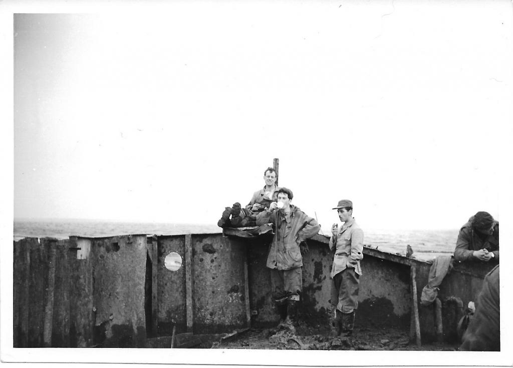
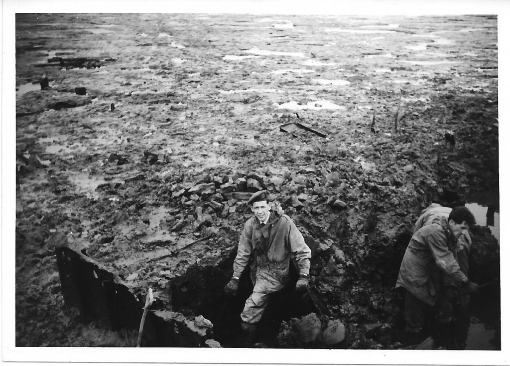
A couple of photos of a bomb disposal job on an old landing craft target at Breast Sands c1964/65.
This image is hidden for guests.
This image is hidden for guests.
This image is hidden for guests.
Please log in or register to see it.
This image is hidden for guests.
Please log in or register to see it.
Please Log in or Create an account to join the conversation.
- Peter Kirk
-

- Offline
- Moderator
-

Less
More
- Posts: 12446
- Thank you received: 1029
15 Aug 2013 21:32 #9
by Peter Kirk
No Amount Of Evidence Will Ever Persuade An Idiot (probably not Mark Twain)
Replied by Peter Kirk on topic Unknown near Terrington, Norfolk
Breast Sands was opened in 1942 for USAAF use and used a pile target. At some point the barge target was added, being further into the Wash NW of the original target. I assume this is the barge that ancientarmourer is referring to. Plans were laid out for extending the range to include a Live bombing and RP range, the live target being to the north of the barge and intended to be a ship. It appears that this never went ahead although nothing states this to be 100% sure. There is mention of Breast Sands being used as a blind bombing target from 1946 into 1949 and this would have increased the danger area to allow for the greater inaccuracy this type of bombing created. This target may have been the barge or more likely a ship, possibly enhanced with radar reflectors. The danger with a lot of TNA files is that proposals are covered in some detail but often fail to extend to implementation or cancellation of these proposals. Even published charts contained proposals that never went ahead!
No Amount Of Evidence Will Ever Persuade An Idiot (probably not Mark Twain)
Please Log in or Create an account to join the conversation.
- Forum
- Open Forum
- Miscellaneous Research Topics
- Where or What is this?
- Unknown near Terrington, Norfolk
Time to create page: 0.061 seconds