- Posts: 10
- Thank you received: 0
- Forum
- Open Forum
- Miscellaneous Research Topics
- Where or What is this?
- Help with this 1944 Navigators Map?
Help with this 1944 Navigators Map?
- Lorne
- Topic Author
- Offline
- New Member
-

Less
More
21 Nov 2013 19:51 #1
by Lorne
Help with this 1944 Navigators Map? was created by Lorne
Greetings to the forum,
I am new to the group and hope that someone will be able to direct me to how to best find answers to some questions. My hobby is studying aviation history and I was pleased to discover your website I am hoping that you will be able to direct me to information on early airfields that I am trying to learn more about. I am trying to find informaton about the WWI, 1912 maneuvers at Jesus Cross (Moulton??). One of the officers aboard the airship Beta II was Thomas Gerard Hetherington when it made an emergency landing there in September 1912. I would like to find out as much as I can about the mishap.
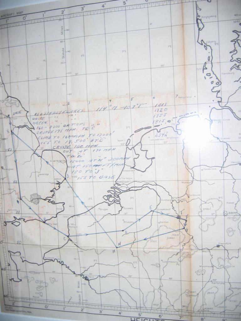
Another question I have is regarding a WWII, navigation map that I have. Can anyone tell me the most likely base from which this bomb run on Dietrichsdorf was made or the squadron which most likely made it? It is late war because the map is dated 1944. Any information would be appreciated. I have no idea of British geography.
I hope I have uploaded the map correctly. If not, please contact me at This email address is being protected from spambots. You need JavaScript enabled to view it. and I can supply more information.
Best regards,
Lorne Bohn
(Canada)
Attached files
This image is hidden for guests.
I am new to the group and hope that someone will be able to direct me to how to best find answers to some questions. My hobby is studying aviation history and I was pleased to discover your website I am hoping that you will be able to direct me to information on early airfields that I am trying to learn more about. I am trying to find informaton about the WWI, 1912 maneuvers at Jesus Cross (Moulton??). One of the officers aboard the airship Beta II was Thomas Gerard Hetherington when it made an emergency landing there in September 1912. I would like to find out as much as I can about the mishap.
Another question I have is regarding a WWII, navigation map that I have. Can anyone tell me the most likely base from which this bomb run on Dietrichsdorf was made or the squadron which most likely made it? It is late war because the map is dated 1944. Any information would be appreciated. I have no idea of British geography.
I hope I have uploaded the map correctly. If not, please contact me at This email address is being protected from spambots. You need JavaScript enabled to view it. and I can supply more information.
Best regards,
Lorne Bohn
(Canada)
Attached files
This image is hidden for guests.
Please log in or register to see it.
Please Log in or Create an account to join the conversation.
- Granite
- Offline
- Senior Member
-

Less
More
- Posts: 186
- Thank you received: 8
21 Nov 2013 20:02 #2
by Granite
Replied by Granite on topic Help with this 1944 Navigators Map?
Hi,
from the map and the location of the start , it looks too far north and west from York to be Linton/Rufforth/Tholthorpe/eastmoor etc, so I'd of probably gone for one of the A1 airfields.. catterick, Dishforth, Scorton, topcliffe, leeming, dalton etc
from the map and the location of the start , it looks too far north and west from York to be Linton/Rufforth/Tholthorpe/eastmoor etc, so I'd of probably gone for one of the A1 airfields.. catterick, Dishforth, Scorton, topcliffe, leeming, dalton etc
Please Log in or Create an account to join the conversation.
- Lorne
- Topic Author
- Offline
- New Member
-
Less
More
- Posts: 10
- Thank you received: 0
21 Nov 2013 20:26 #3
by Lorne
Thank you for your reply. Can you direct me to the correct subforum to find out which airfield this is?
Best regards,
Lorne
Replied by Lorne on topic Help with this 1944 Navigators Map?
Hi,
from the map and the location of the start , it looks too far north and west from York to be Linton/Rufforth/Tholthorpe/eastmoor etc, so I'd of probably gone for one of the A1 airfields.. catterick, Dishforth, Scorton, topcliffe, leeming, dalton etc
Thank you for your reply. Can you direct me to the correct subforum to find out which airfield this is?
Best regards,
Lorne
Please Log in or Create an account to join the conversation.
- Viscount 701
- Offline
- Junior Member
-

Less
More
- Posts: 23
- Thank you received: 0
21 Nov 2013 20:46 #4
by Viscount 701
Replied by Viscount 701 on topic Help with this 1944 Navigators Map?
Got out my out of date, but modern air map. Tried to follow the rivers, but failed, so looked at the clearly drawn lines of lat and long.
Just above 54 degrees North (say 54 degrees 5 minutes North)
Just to the west of 1 degree West (say 1 degree 15 minutes West)
Just north of a major regional river, which is presumably the River Ouse/River Ure
Brings me to a point immediately north west of York, in the region of the village of Shipton. But a little south west of the airfield of East Moor. While Linton on Ouse looks a little further off, too far west in longitude terms, but fits the just north of a river location very neatly. However need a map of wartime airfields not current or currently disused ones.
So intrigued with the task, been up into the loft to find my father's 1940s RAF navigation maps, however none cover the area just north of York; south of 54N, no problem!
Interesting little question. Thought I could pin the answer, but haven't!
My old world Atlas does not have the detail to confirm the target 'T'.
From a relative newcomer myself, welcome.
Just above 54 degrees North (say 54 degrees 5 minutes North)
Just to the west of 1 degree West (say 1 degree 15 minutes West)
Just north of a major regional river, which is presumably the River Ouse/River Ure
Brings me to a point immediately north west of York, in the region of the village of Shipton. But a little south west of the airfield of East Moor. While Linton on Ouse looks a little further off, too far west in longitude terms, but fits the just north of a river location very neatly. However need a map of wartime airfields not current or currently disused ones.
So intrigued with the task, been up into the loft to find my father's 1940s RAF navigation maps, however none cover the area just north of York; south of 54N, no problem!
Interesting little question. Thought I could pin the answer, but haven't!
My old world Atlas does not have the detail to confirm the target 'T'.
From a relative newcomer myself, welcome.
Please Log in or Create an account to join the conversation.
- kebecker
-

- Offline
- Platinum Member
-

Less
More
- Posts: 2942
- Thank you received: 508
21 Nov 2013 20:47 #5
by kebecker
I reckon it could be Linton on Ouse ,
Welcome to AIX by the way
Replied by kebecker on topic Help with this 1944 Navigators Map?
Thank you for your reply. Can you direct me to the correct subforum to find out which airfield this is?
Best regards,
Lorne
I reckon it could be Linton on Ouse ,
Welcome to AIX by the way
Please Log in or Create an account to join the conversation.
- Lorne
- Topic Author
- Offline
- New Member
-
Less
More
- Posts: 10
- Thank you received: 0
21 Nov 2013 22:21 #6
by Lorne
Replied by Lorne on topic Help with this 1944 Navigators Map?
Thanks for your reply and for the welcome. As near as I can tell, the target was Dietrichsdorf.
Got out my out of date, but modern air map. Tried to follow the rivers, but failed, so looked at the clearly drawn lines of lat and long.
Just above 54 degrees North (say 54 degrees 5 minutes North)
Just to the west of 1 degree West (say 1 degree 15 minutes West)
Just north of a major regional river, which is presumably the River Ouse/River Ure
Brings me to a point immediately north west of York, in the region of the village of Shipton. But a little south west of the airfield of East Moor. While Linton on Ouse looks a little further off, too far west in longitude terms, but fits the just north of a river location very neatly. However need a map of wartime airfields not current or currently disused ones.
So intrigued with the task, been up into the loft to find my father's 1940s RAF navigation maps, however none cover the area just north of York; south of 54N, no problem!
Interesting little question. Thought I could pin the answer, but haven't!
My old world Atlas does not have the detail to confirm the target 'T'.
From a relative newcomer myself, welcome.
Please Log in or Create an account to join the conversation.
- netcompsys
-

- Offline
- Moderator
-

Less
More
- Posts: 5566
- Thank you received: 1369
22 Nov 2013 00:05 #7
by netcompsys
kevin
Replied by netcompsys on topic Help with this 1944 Navigators Map?
This thread is going a bit off track
I am not sure how you got the target to be Dietrichsdorf. The Target, waypoint T looks more like Cologne to me. Bomber command visited Cologne on a number of occasions in 1944/45
Since the starting point was Yorkshire, it would probably be Halifaxes
eg
kevin
I am not sure how you got the target to be Dietrichsdorf. The Target, waypoint T looks more like Cologne to me. Bomber command visited Cologne on a number of occasions in 1944/45
Since the starting point was Yorkshire, it would probably be Halifaxes
eg
2 March 1945
858 aircraft - 531 Lancasters, 303 Halifaxes, 24 Mosquitos - raided Cologne in 2 waves. 6 Lancasters and 2 Halifaxes were lost and 1 Halifax crashed in Belgium. The first raid was carried out by 703 aircraft and the second by 155 Lancasters of No 3 Group. In the second raid, however, only 15 aircraft bombed, because the G-H station in England was not working correctly. The main raid was highly destructive, with the Pathfinders marking in clear weather conditions. This was the last RAF raid on Cologne, which was captured by American troops 4 days later.
kevin
kevin
Please Log in or Create an account to join the conversation.
- P Bellamy
-

- Offline
- Platinum Member
-
Less
More
- Posts: 4566
- Thank you received: 323
22 Nov 2013 00:27 #8
by P Bellamy
Paul Bellamy
Replied by P Bellamy on topic Help with this 1944 Navigators Map?
Target "T" would indeed appear to be Cologne.
"Base" seems to be either Linton-on-Ouse, Tolthorpe or East Moor, the three stations of 62 (Beaver) Base under 6 Group (RCAF), Bomber Command.
All the best,
PB
"Base" seems to be either Linton-on-Ouse, Tolthorpe or East Moor, the three stations of 62 (Beaver) Base under 6 Group (RCAF), Bomber Command.
All the best,
PB
Paul Bellamy
Please Log in or Create an account to join the conversation.
- Lorne
- Topic Author
- Offline
- New Member
-
Less
More
- Posts: 10
- Thank you received: 0
22 Nov 2013 00:46 #9
by Lorne
Replied by Lorne on topic Help with this 1944 Navigators Map?
I think you are correct Kevin. I just took another look at the map and the flight path is drawn right through the word "Koln".
Do you have any more information on this? ie. Squadron's involved? The return base does not appear to be the same as the one from which they departed. Was this a common practice? I am not familiar with the term "G-H Station"? Koln was the first times 1000 allied bombers were used as well isn't it? I can only imagine the logistics involved with trying to have a large number of fully loaded bombers climb to close to 20,000 feet in such a short distance. By 1945, I am sure they were detected well before they crossed the channel and the LW probably had a pretty good idea of what the intended targets were likely to be. It's a fascinating topic and I am just beginning to learn about it.
Thanks again.
Lorne
Do you have any more information on this? ie. Squadron's involved? The return base does not appear to be the same as the one from which they departed. Was this a common practice? I am not familiar with the term "G-H Station"? Koln was the first times 1000 allied bombers were used as well isn't it? I can only imagine the logistics involved with trying to have a large number of fully loaded bombers climb to close to 20,000 feet in such a short distance. By 1945, I am sure they were detected well before they crossed the channel and the LW probably had a pretty good idea of what the intended targets were likely to be. It's a fascinating topic and I am just beginning to learn about it.
Thanks again.
Lorne
This thread is going a bit off track
I am not sure how you got the target to be Dietrichsdorf. The Target, waypoint T looks more like Cologne to me. Bomber command visited Cologne on a number of occasions in 1944/45
Since the starting point was Yorkshire, it would probably be Halifaxes
eg
kevin
Please Log in or Create an account to join the conversation.
- Lorne
- Topic Author
- Offline
- New Member
-
Less
More
- Posts: 10
- Thank you received: 0
22 Nov 2013 01:06 #10
by Lorne
Replied by Lorne on topic Help with this 1944 Navigators Map?
Thanks for narrowing this down for me. Much appreciated.
Target "T" would indeed appear to be Cologne.
"Base" seems to be either Linton-on-Ouse, Tolthorpe or East Moor, the three stations of 62 (Beaver) Base under 6 Group (RCAF), Bomber Command.
All the best,
PB
Please Log in or Create an account to join the conversation.
- Forum
- Open Forum
- Miscellaneous Research Topics
- Where or What is this?
- Help with this 1944 Navigators Map?
Time to create page: 0.057 seconds