- Posts: 371
- Thank you received: 1
- Forum
- Open Forum
- Miscellaneous Research Topics
- General Airfield or 20th Century Military Architecture Discussion Topics
- RAF 'Y' Stations etc. Discussion Thread
RAF 'Y' Stations etc. Discussion Thread
- Jenna
- Offline
- Senior Member
-

Less
More
15 Sep 2011 13:32 #51
by Jenna
Replied by Jenna on topic RAF 'Y' Stations etc.
Bletchley is having a major rework, new management and a big swap round in who there (the sub organisations)... some even being kicked off site!
A bit of a side shoot but I have now located what I'm fairly sure is Arkley View SCU.
www.flashearth.com/?lat=51.650636&lon=-0...&z=19.2&r=0&src="msl"
added to my google map too.
/community/showthread.php?6672-Bedfordshires-hidden-WWII-past ...
A bit of a side shoot but I have now located what I'm fairly sure is Arkley View SCU.
www.flashearth.com/?lat=51.650636&lon=-0...&z=19.2&r=0&src="msl"
added to my google map too.
/community/showthread.php?6672-Bedfordshires-hidden-WWII-past ...
Please Log in or Create an account to join the conversation.
- Stan Ames
- Offline
- New Member
-

Less
More
- Posts: 19
- Thank you received: 0
16 Sep 2011 09:06 #52
by Stan Ames
Replied by Stan Ames on topic RAF 'Y' Stations etc.
Dear Jenna
Arkley view was very close to the bulding in your picture, that was called Arkely Lodge and was also used by RSS. Arkley view was to the left and further back from the road. I have a 1946 aerial photo that shows the house and the intercept building behind it. As it grew in size and importance during WW2 they took over many of the local houses.
[IMG]/community/84044=5930-Arkley View2.jpg[/img]
In this picture Arkley Lodge is near the right hand edge. It was much smaller than it is now. Arkley View itself seems to have been demolished to build a group of new houses. You can see WW2 photos of the front and rear of Arkely View at www.secretlisteners.org .
All best
Stan
Arkley view was very close to the bulding in your picture, that was called Arkely Lodge and was also used by RSS. Arkley view was to the left and further back from the road. I have a 1946 aerial photo that shows the house and the intercept building behind it. As it grew in size and importance during WW2 they took over many of the local houses.
[IMG]/community/84044=5930-Arkley View2.jpg[/img]
In this picture Arkley Lodge is near the right hand edge. It was much smaller than it is now. Arkley View itself seems to have been demolished to build a group of new houses. You can see WW2 photos of the front and rear of Arkely View at www.secretlisteners.org .
All best
Stan
Please Log in or Create an account to join the conversation.
- Jenna
- Offline
- Senior Member
-
Less
More
- Posts: 371
- Thank you received: 1
16 Sep 2011 10:28 #53
by Jenna
Replied by Jenna on topic RAF 'Y' Stations etc.
Excellent information Stan, many thanks.
Thanks to Stan's info I managed to get my hands on some of the local archive and can add a bit more....
The house I have highlighted is 'Oaklands' and 'Arkley View' was across the road under the houses built in 1964.
"Oaklands was the administrative section and orderly room whilst the sergeants' mess was in Scotswood on the opposite side of the main road. Various large houses such as The Lawns,
Rowley Lodge and Meadow Bank were used as billets" from Bob King (G3ASE) notes.
Another location nailed down, thanks Stan.
GE with pre 1964 map overlay.
This image is hidden for guests.
OS pre war map
This image is hidden for guests.
pre war map with 1964 builders overlay
This image is hidden for guests.
Thanks to Stan's info I managed to get my hands on some of the local archive and can add a bit more....
The house I have highlighted is 'Oaklands' and 'Arkley View' was across the road under the houses built in 1964.
"Oaklands was the administrative section and orderly room whilst the sergeants' mess was in Scotswood on the opposite side of the main road. Various large houses such as The Lawns,
Rowley Lodge and Meadow Bank were used as billets" from Bob King (G3ASE) notes.
Another location nailed down, thanks Stan.
GE with pre 1964 map overlay.
This image is hidden for guests.
Please log in or register to see it.
OS pre war map
This image is hidden for guests.
Please log in or register to see it.
pre war map with 1964 builders overlay
This image is hidden for guests.
Please log in or register to see it.
Please Log in or Create an account to join the conversation.
- Stan Ames
- Offline
- New Member
-
Less
More
- Posts: 19
- Thank you received: 0
18 Sep 2011 15:33 #54
by Stan Ames
Replied by Stan Ames on topic RAF 'Y' Stations etc.
Jenna
A nice piece of research and a nifty piece of map overlay, excellent.
Your sources are impeccable too, you can't get better than Bob King, he was there on the spot at the time.
RSS seem to have taken over most of the large houses in Arkley for one use or another. I wonder what the locals thought was going on! They were all in Royal Signals uniform so nobody would have known they worked for MI6.
All best
Stan
A nice piece of research and a nifty piece of map overlay, excellent.
Your sources are impeccable too, you can't get better than Bob King, he was there on the spot at the time.
RSS seem to have taken over most of the large houses in Arkley for one use or another. I wonder what the locals thought was going on! They were all in Royal Signals uniform so nobody would have known they worked for MI6.
All best
Stan
Please Log in or Create an account to join the conversation.
- HF Dave
-

- Offline
- Senior Member
-
Less
More
- Posts: 365
- Thank you received: 30
28 Sep 2011 20:25 #55
by HF Dave
Replied by HF Dave on topic RAF 'Y' Stations etc.
No mention of Bedell's End, near Chelmsford in Essex?
I know this site was later used by the Marconi Company for DF / radar research, but was it originally a WWII intercept site?
I know this site was later used by the Marconi Company for DF / radar research, but was it originally a WWII intercept site?
Please Log in or Create an account to join the conversation.
- ColinBa
- Offline
- Senior Member
-
Less
More
- Posts: 377
- Thank you received: 13
28 Sep 2011 21:37 #56
by ColinBa
Replied by ColinBa on topic RAF 'Y' Stations etc.
Some years ago David Hare wrote a play for TV Licking Hitler about this era. It was almost impossible to obtain until I spotted this
www.stojo.com/PFT_Hitler_Stockers.html
It is a copy from VHS but view-able. Stocker's Copper was also one of the best plays of its generation
www.stojo.com/PFT_Hitler_Stockers.html
It is a copy from VHS but view-able. Stocker's Copper was also one of the best plays of its generation
Please Log in or Create an account to join the conversation.
- carnaby
-
 Topic Author
- Offline
- Platinum Member
-

Less
More
- Posts: 5026
- Thank you received: 440
29 Sep 2011 07:52 #57
by carnaby
Don't think Bedell's End was a Y Station, though I am still working through some 'new' ones not in the audit. I assume your site is somewhere around HERE ,
There was an Interservice station at Chelmsford close to HERE .
Plan A is always more effective when the problem you are working on understands that Plan B will involve the use of dynamite
Replied by carnaby on topic RAF 'Y' Stations etc.
Welcome to Aix Dave.No mention of Bedell's End, near Chelmsford in Essex?
I know this site was later used by the Marconi Company for DF / radar research, but was it originally a WWII intercept site?
Don't think Bedell's End was a Y Station, though I am still working through some 'new' ones not in the audit. I assume your site is somewhere around HERE ,
There was an Interservice station at Chelmsford close to HERE .
Plan A is always more effective when the problem you are working on understands that Plan B will involve the use of dynamite
Please Log in or Create an account to join the conversation.
- HF Dave
-
- Offline
- Senior Member
-
Less
More
- Posts: 365
- Thank you received: 30
29 Sep 2011 11:52 #58
by HF Dave
Thanks.
I would say both those locations are 'Bedells End', a general area within Writtle, to the west of Chelmsford.
The site is listed as SMR 15939 (see unlockingessex.essexcc.gov.uk for example) where it is mentioned that it 'may' have opened during WWII. There was certainly an underground bunker, though this may have been constructed for a later radar system. There is nothing there to see today, other than a short stretch of tarmac.
Replied by HF Dave on topic RAF 'Y' Stations etc.
Welcome to Aix Dave.
Don't think Bedell's End was a Y Station, though I am still working through some 'new' ones not in the audit. I assume your site is somewhere around HERE ,
There was an Interservice station at Chelmsford close to HERE .
Thanks.
I would say both those locations are 'Bedells End', a general area within Writtle, to the west of Chelmsford.
The site is listed as SMR 15939 (see unlockingessex.essexcc.gov.uk for example) where it is mentioned that it 'may' have opened during WWII. There was certainly an underground bunker, though this may have been constructed for a later radar system. There is nothing there to see today, other than a short stretch of tarmac.
Please Log in or Create an account to join the conversation.
- carnaby
-
Topic Author
- Offline
- Platinum Member
-
Less
More
- Posts: 5026
- Thank you received: 440
29 Sep 2011 14:45 - 08 Sep 2017 14:32 #59
by carnaby
Plan A is always more effective when the problem you are working on understands that Plan B will involve the use of dynamite
Replied by carnaby on topic RAF 'Y' Stations etc.
I suspect the Marconi D/F station used the site of the wartime 'Y' station which was at wM 124272 (=TL 678085)
The corresponding station at Ford End was wM 102352 (TL6564165) The control room was at wM 121344 (TL665157)
Source: TNA HW41/401
I note that Flight magazine states Bedells End is near Cheltenham ! (oops)
www.flightglobal.com/pdfarchive/view/1959/1959 - 3467.html
The corresponding station at Ford End was wM 102352 (TL6564165) The control room was at wM 121344 (TL665157)
Source: TNA HW41/401
I note that Flight magazine states Bedells End is near Cheltenham ! (oops)
www.flightglobal.com/pdfarchive/view/1959/1959 - 3467.html
Plan A is always more effective when the problem you are working on understands that Plan B will involve the use of dynamite
Last edit: 08 Sep 2017 14:32 by carnaby. Reason: Post corrupted
Please Log in or Create an account to join the conversation.
- Stan Ames
- Offline
- New Member
-
Less
More
- Posts: 19
- Thank you received: 0
03 Oct 2011 22:13 #60
by Stan Ames
Replied by Stan Ames on topic RAF 'Y' Stations etc.
There are records of an HF DF station at Bedells End, it was described as an Interservice Research facility. It was located on the western edge of current Chelmsford a few 100m north of the A1060 Roxwell Rd. The site continued to be used by Marconi after WW2 for aviation radio research.
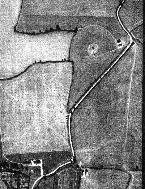
The 5 DF stations at Ford End were very interesting. They were built in the latter stages of WW2 to get more accurate fixes on U-boats and continued well after WW2 under Composite Signals. The only information I have about its post war work is that at least one of the operators spoke fluent Russian! If you look on Google satellite you will see the original control rooms still present (two nissen huts end to end) near the junction of Pleshey Rd and Park Rd south of Ford End. 1946 aerial photo of the 2 control rooms near the bottom and one of the DF stations attached.
This image is hidden for guests.
Stan
The 5 DF stations at Ford End were very interesting. They were built in the latter stages of WW2 to get more accurate fixes on U-boats and continued well after WW2 under Composite Signals. The only information I have about its post war work is that at least one of the operators spoke fluent Russian! If you look on Google satellite you will see the original control rooms still present (two nissen huts end to end) near the junction of Pleshey Rd and Park Rd south of Ford End. 1946 aerial photo of the 2 control rooms near the bottom and one of the DF stations attached.
This image is hidden for guests.
Please log in or register to see it.
Stan
Please Log in or Create an account to join the conversation.
- Forum
- Open Forum
- Miscellaneous Research Topics
- General Airfield or 20th Century Military Architecture Discussion Topics
- RAF 'Y' Stations etc. Discussion Thread
Time to create page: 0.057 seconds

![[IMG]/community/84044=5930-Arkley View2.jpg[/img]](/community/84044=5930-Arkley%20View2.jpg)